Make a donation
Gear up for your next adventure:
As an Amazon Associate, this site earns from qualifying purchases at no extra cost to you.
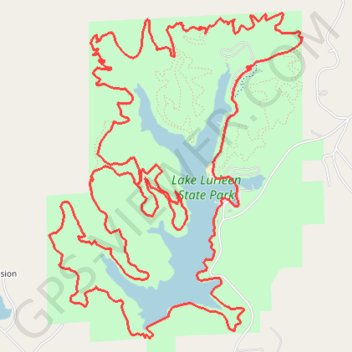
Lake Lurleen MTB Loop
Mountain Bike loop around the Lake Lurleen. Lake Lurleen State Park. #MTB #Loop #Lake #Forest #Nature
- Distance: 22.0 Km
- Elevation gain: 381 m
- Maximum elevation: 131 m
- Elevation loss: 381 m
- Minimum elevation: 64 m
- Moving time: 2 h 50 m
- Moving speed: 7.7 Km/h
- Maximum speed: 41.0 Km/h
- Total time: 3 h 37 m
- Global speed: 6.1 Km/h
Interactive trail map
Make a donation
Gear up for your next adventure:
As an Amazon Associate, this site earns from qualifying purchases at no extra cost to you.
Trail profile
- Distance: 22.0 Km
- Elevation gain: 381 m
- Maximum elevation: 131 m
- Elevation loss: 381 m
- Minimum elevation: 64 m
- Moving time: 2 h 50 m
- Moving speed: 7.7 Km/h
- Maximum speed: 41.0 Km/h
- Total time: 3 h 37 m
- Global speed: 6.1 Km/h
Make a donation
Gear up for your next adventure:
As an Amazon Associate, this site earns from qualifying purchases at no extra cost to you.
About this trail
Name: Lake Lurleen MTB Loop trail, distance, elevation, map, profile, GPS track
Start: Lakeside Trail, Tuscaloosa County, Alabama, United States (33.29712 -87.67710)
End: Lakeside Trail, Tuscaloosa County, Alabama, United States (33.29716 -87.67705)
Coordinates: 33.28559 -87.69485 33.31351 -87.66882
Make a donation
Gear up for your next adventure:
As an Amazon Associate, this site earns from qualifying purchases at no extra cost to you.