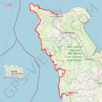
GR223 - Cherbourg à Coutances
https://en-hk.gps-viewer.com/track-217rr/GR223-Cherbourg-à-Coutances/
- Distance: 201.4 Km
- Elevation gain: 2,088 m
- Maximum elevation: 138 m
- Elevation loss: 2,043 m
- Minimum elevation: -1 m
Interactive trail map
Trail profile
- Distance: 201.4 Km
- Elevation gain: 2,088 m
- Maximum elevation: 138 m
- Elevation loss: 2,043 m
- Minimum elevation: -1 m
About this trail
Name: GR223 - Cherbourg à Coutances trail, distance, elevation, map, profile, GPS track
Coordinates: 49.00176 -1.94747 49.72691 -1.44202