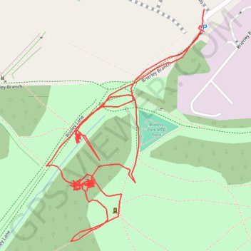
RE SK480600
- Distance: 2.4 Km
- Elevation gain: 42 m
- Maximum elevation: 183 m
- Elevation loss: 42 m
- Minimum elevation: 168 m
- Moving time: 39 m 10 s
- Moving speed: 3.6 Km/h
- Maximum speed: 7.4 Km/h
- Total time: 3 h 58 m
- Global speed: 0.6 Km/h
Interactive trail map
Trail profile
- Distance: 2.4 Km
- Elevation gain: 42 m
- Maximum elevation: 183 m
- Elevation loss: 42 m
- Minimum elevation: 168 m
- Moving time: 39 m 10 s
- Moving speed: 3.6 Km/h
- Maximum speed: 7.4 Km/h
- Total time: 3 h 58 m
- Global speed: 0.6 Km/h
About this trail
Name: RE SK480600 trail, distance, elevation, map, profile, GPS track
Coordinates: 53.13416 -1.28468 53.13768 -1.28070
Other hiking, mountain biking, running and outdoor activity trails
Click on a trail to view its statistics, map and profile.
RE SK480600
United Kingdom > England > Nottinghamshire > Ashfield > Sutton in Ashfield > Stanton Hill
Distance: 1.1 Km • Elevation gain: 7 m • Maximum elevation: 180 m
RE SK480600 2
United Kingdom > England > Nottinghamshire > Ashfield > Sutton in Ashfield > Stanton Hill
Distance: 0.8 Km • Elevation gain: 7 m • Maximum elevation: 179 m