West Fork Trail along West Fork Oak Creek in Red Rock-Secret Mountain Wilderness
The West Fork Trail is a gem for hikers looking to escape the Arizona sun, as the towering canyon walls and lush tree cover create a cool and inviting atmosphere. Following the creek, you'll navigate delightful stream crossings that add a fun challenge while being rewarded with stunning views of red rock formations and serene pools along the way. Whether you’re there for a leisurely stroll or a more adventurous exploration, this trail's scenic beauty makes every step worthwhile. #Hiking #Canyon #River #Forest #Nature #Rock
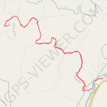
- Distance: 11.7 Km
- Elevation gain: 466 m
- Maximum elevation: 1,757 m
- Elevation loss: 466 m
- Minimum elevation: 1,618 m
- Moving time: 3 h 1 m
- Moving speed: 3.9 Km/h
- Maximum speed: 19.0 Km/h
- Total time: 3 h 15 m
- Global speed: 3.6 Km/h
Interactive trail map
Trail profile
- Distance: 11.7 Km
- Elevation gain: 466 m
- Maximum elevation: 1,757 m
- Elevation loss: 466 m
- Minimum elevation: 1,618 m
- Moving time: 3 h 1 m
- Moving speed: 3.9 Km/h
- Maximum speed: 19.0 Km/h
- Total time: 3 h 15 m
- Global speed: 3.6 Km/h
About this trail
Name: West Fork Trail along West Fork Oak Creek in Red Rock-Secret Mountain Wilderness trail, distance, elevation, map, profile, GPS track
Start: West Fork Trail, Coconino County, Arizona, United States (34.99087 -111.74277)
End: West Fork Trail, Coconino County, Arizona, United States (34.99066 -111.74281)
Coordinates: 34.98795 -111.76930 35.00440 -111.74277
Other hiking, mountain biking, running and outdoor activity trails
Click on a trail to view its statistics, map and profile.
West Fork Trail in Coconino National Forest
United States > Arizona > Coconino County
The West Fork Trail is a captivating hike that offers a blend of scenic beauty and natural history. The trail meanders along the West Fork of Oak Creek, providing stunning views of the red rock cliffs, dense forests of Douglas firs, and vibrant riparian flora. Throughout the route, hikers will encounter…
Distance: 9.7 Km • Elevation gain: 326 m • Maximum elevation: 1,736 m