Make a donation
Gear up for your next adventure:
As an Amazon Associate, this site earns from qualifying purchases at no extra cost to you.
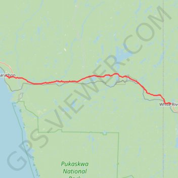
Marathon - White River
- Distance: 90.2 Km
- Elevation gain: 751 m
- Maximum elevation: 407 m
- Elevation loss: 612 m
- Minimum elevation: 189 m
Interactive trail map
Make a donation
Gear up for your next adventure:
As an Amazon Associate, this site earns from qualifying purchases at no extra cost to you.
Trail profile
- Distance: 90.2 Km
- Elevation gain: 751 m
- Maximum elevation: 407 m
- Elevation loss: 612 m
- Minimum elevation: 189 m
Make a donation
Gear up for your next adventure:
As an Amazon Associate, this site earns from qualifying purchases at no extra cost to you.
About this trail
Name: Marathon - White River trail, distance, elevation, map, profile, GPS track
Coordinates: 48.59451 -86.36501 48.72462 -85.27878
Topography: Thunder Bay District topographic map, elevation, terrain
Make a donation
Gear up for your next adventure:
As an Amazon Associate, this site earns from qualifying purchases at no extra cost to you.
Other hiking, mountain biking, running and outdoor activity trails
Click on a trail to view its statistics, map and profile.
Terrace Bay - Marathon
Canada > Ontario > Thunder Bay District > Terrace Bay Township
Lake Superior. #Bike #TerraceBay #Marathon #LakeSuperior
Distance: 83.0 Km • Elevation gain: 1,081 m • Maximum elevation: 322 m