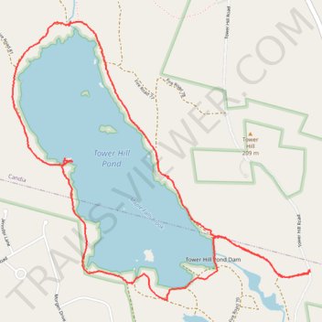
Trail around Tower Hill Pond, near Manchester NH
- Distance: 6.8 Km
- Elevation gain: 78 m
- Maximum elevation: 113 m
- Elevation loss: 76 m
- Minimum elevation: 94 m
- Moving time: 1 h 49 m
- Moving speed: 3.7 Km/h
- Maximum speed: 16.6 Km/h
- Total time: 2 h 4 m
- Global speed: 3.3 Km/h
Interactive trail map
Trail profile
- Distance: 6.8 Km
- Elevation gain: 78 m
- Maximum elevation: 113 m
- Elevation loss: 76 m
- Minimum elevation: 94 m
- Moving time: 1 h 49 m
- Moving speed: 3.7 Km/h
- Maximum speed: 16.6 Km/h
- Total time: 2 h 4 m
- Global speed: 3.3 Km/h
About this trail
Name: Trail around Tower Hill Pond, near Manchester NH trail, distance, elevation, map, profile, GPS track
Start: Tower Hill Road, Auburn, Rockingham County, New Hampshire, 03034, United States (43.03365 -71.35740)
Coordinates: 43.03221 -71.37984 43.04767 -71.35721
Other hiking, mountain biking, running and outdoor activity trails
Click on a trail to view its statistics, map and profile.
2026-06-23_11-48_Tue
United States > New Hampshire > Hillsborough County > Goffstown > Grasmere
Distance: 70.3 Km • Elevation gain: 643 m • Maximum elevation: 140 m