Thank you for supporting this site ❤️
Make a donation
Make a donation
Gear up for your next adventure:
As an Amazon Associate, this site earns from qualifying purchases at no extra cost to you.
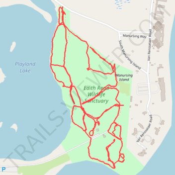
Edith Read Wildlife Sanctuary trails
- Distance: 5.8 Km
- Elevation gain: 27 m
- Maximum elevation: 11 m
- Elevation loss: 30 m
- Minimum elevation: 0 m
Interactive trail map
Thank you for supporting this site ❤️
Make a donation
Make a donation
Gear up for your next adventure:
As an Amazon Associate, this site earns from qualifying purchases at no extra cost to you.
Trail profile
- Distance: 5.8 Km
- Elevation gain: 27 m
- Maximum elevation: 11 m
- Elevation loss: 30 m
- Minimum elevation: 0 m
Thank you for supporting this site ❤️
Make a donation
Make a donation
Gear up for your next adventure:
As an Amazon Associate, this site earns from qualifying purchases at no extra cost to you.
About this trail
Name: Edith Read Wildlife Sanctuary trails trail, distance, elevation, map, profile, GPS track
Coordinates: 40.96708 -73.66728 40.97440 -73.66287
Thank you for supporting this site ❤️
Make a donation
Make a donation
Gear up for your next adventure:
As an Amazon Associate, this site earns from qualifying purchases at no extra cost to you.
Other hiking, mountain biking, running and outdoor activity trails
Click on a trail to view its statistics, map and profile.