Irvington Woods (West) Track
- Distance: 8.4 Km
- Elevation gain: 170 m
- Maximum elevation: 145 m
- Elevation loss: 171 m
- Minimum elevation: 87 m
- Moving time: 1 h 51 m
- Moving speed: 4.5 Km/h
- Maximum speed: 10.9 Km/h
- Total time: 2 h 6 m
- Global speed: 4.0 Km/h
Interactive trail map
Trail profile
- Distance: 8.4 Km
- Elevation gain: 170 m
- Maximum elevation: 145 m
- Elevation loss: 171 m
- Minimum elevation: 87 m
- Moving time: 1 h 51 m
- Moving speed: 4.5 Km/h
- Maximum speed: 10.9 Km/h
- Total time: 2 h 6 m
- Global speed: 4.0 Km/h
About this trail
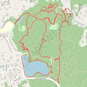
Name: Irvington Woods (West) Track trail, distance, elevation, map, profile, GPS track
Coordinates: 41.03377 -73.85347 41.04247 -73.84533
Other hiking, mountain biking, running and outdoor activity trails
Click on a trail to view its statistics, map and profile.
Irvington Woods South
United States > New York > Westchester County > Village of Irvington
Distance: 6.3 Km • Elevation gain: 189 m • Maximum elevation: 135 m