Rando-raquettes à La Vatay
- Distance: 8.5 Km
- Elevation gain: 246 m
- Maximum elevation: 1,438 m
- Elevation loss: 254 m
- Minimum elevation: 1,260 m
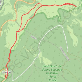
Interactive trail map
Trail profile
- Distance: 8.5 Km
- Elevation gain: 246 m
- Maximum elevation: 1,438 m
- Elevation loss: 254 m
- Minimum elevation: 1,260 m
About this trail
Name: Rando-raquettes à La Vatay trail, distance, elevation, map, profile, GPS track
Coordinates: 46.38713 6.05283 46.41001 6.08394
Other hiking, mountain biking, running and outdoor activity trails
Click on a trail to view its statistics, map and profile.
PT23DS2 Lörrach → Cadaqués
Germany > Baden-Württemberg > Landkreis Lörrach > Lörrach (Kernstadt)
Distance: 1,050.7 Km • Elevation gain: 13,130 m • Maximum elevation: 1,505 m