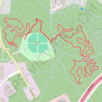
Southside Park MTB Loop
Interactive trail map
Trail profile
- Distance: 7.8 Km
- Elevation gain: 85 m
- Maximum elevation: 278 m
- Elevation loss: 85 m
- Minimum elevation: 252 m
- Moving time: 59 m 30 s
- Moving speed: 7.9 Km/h
- Maximum speed: 24.4 Km/h
- Total time: 59 m 30 s
- Global speed: 7.9 Km/h
About this trail
Name: Southside Park MTB Loop trail, distance, elevation, map, profile, GPS track
Coordinates: 33.65800 -84.37322 33.66460 -84.36189
Other hiking, mountain biking, running and outdoor activity trails
Click on a trail to view its statistics, map and profile.
Atlanta, Lilburn, Yellow River Park, Panola, Jonesboro
United States > Georgia > Fayette County > Peachtree City > Stop
Distance: 335.0 Km • Elevation gain: 4,058 m • Maximum elevation: 338 m
Morrow, Forest Park, Atlanta, Fairburn
United States > Georgia > Fayette County > Peachtree City
Distance: 186.0 Km • Elevation gain: 1,824 m • Maximum elevation: 325 m