Make a donation
Gear up for your next adventure:
As an Amazon Associate, this site earns from qualifying purchases at no extra cost to you.
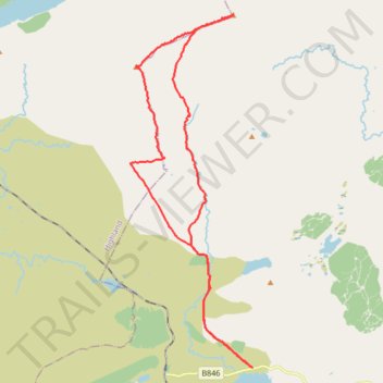
Walk up Carn Dearg and Sgor Gaibhre from near Loch Eigheach
- Distance: 26.9 Km
- Elevation gain: 961 m
- Maximum elevation: 954 m
- Elevation loss: 961 m
- Minimum elevation: 264 m
- Moving time: 6 h 25 m
- Moving speed: 4.2 Km/h
- Maximum speed: 6.6 Km/h
- Total time: 7 h 24 m
- Global speed: 3.6 Km/h
Interactive trail map
Make a donation
Gear up for your next adventure:
As an Amazon Associate, this site earns from qualifying purchases at no extra cost to you.
Trail profile
- Distance: 26.9 Km
- Elevation gain: 961 m
- Maximum elevation: 954 m
- Elevation loss: 961 m
- Minimum elevation: 264 m
- Moving time: 6 h 25 m
- Moving speed: 4.2 Km/h
- Maximum speed: 6.6 Km/h
- Total time: 7 h 24 m
- Global speed: 3.6 Km/h
Make a donation
Gear up for your next adventure:
As an Amazon Associate, this site earns from qualifying purchases at no extra cost to you.
About this trail
Name: Walk up Carn Dearg and Sgor Gaibhre from near Loch Eigheach trail, distance, elevation, map, profile, GPS track
Start: B846, Perth and Kinross, Scotland, United Kingdom (56.68636 -4.53815)
End: B846, Perth and Kinross, Scotland, United Kingdom (56.68638 -4.53813)
Coordinates: 56.68631 -4.59241 56.77265 -4.53802
Make a donation
Gear up for your next adventure:
As an Amazon Associate, this site earns from qualifying purchases at no extra cost to you.
Other hiking, mountain biking, running and outdoor activity trails
Click on a trail to view its statistics, map and profile.
Munro Hillwalk - Meall na Meoig, Sgòr Gaibhre, Sgòr Choinnich and Carn Dearg loop from Loch Heigheach
United Kingdom > Scotland > Perth and Kinross
Distance: 27.4 Km • Elevation gain: 1,234 m • Maximum elevation: 955 m