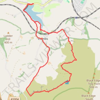
High Peak Hiking
- Distance: 13.5 Km
- Elevation gain: 404 m
- Maximum elevation: 482 m
- Elevation loss: 404 m
- Minimum elevation: 211 m
- Moving time: 3 h 42 m
- Moving speed: 3.6 Km/h
- Maximum speed: 6.7 Km/h
- Total time: 4 h 16 m
- Global speed: 3.2 Km/h
Interactive trail map
Trail profile
- Distance: 13.5 Km
- Elevation gain: 404 m
- Maximum elevation: 482 m
- Elevation loss: 404 m
- Minimum elevation: 211 m
- Moving time: 3 h 42 m
- Moving speed: 3.6 Km/h
- Maximum speed: 6.7 Km/h
- Total time: 4 h 16 m
- Global speed: 3.2 Km/h
About this trail
Name: High Peak Hiking trail, distance, elevation, map, profile, GPS track
Coordinates: 53.28307 -1.95109 53.31718 -1.91820
Other hiking, mountain biking, running and outdoor activity trails
Click on a trail to view its statistics, map and profile.
Combs Loop from Reservoir
United Kingdom > England > Derbyshire > High Peak > Chapel-en-le-Frith > Combs > Tunstead Milton
Distance: 13.2 Km • Elevation gain: 402 m • Maximum elevation: 482 m