Thank you for supporting this site ❤️
Make a donation
Make a donation
Gear up for your next adventure:
As an Amazon Associate, this site earns from qualifying purchases at no extra cost to you.
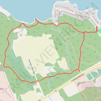
Shirleys Bay - Trail 10 Loop Walk
- Distance: 5.1 Km
- Elevation gain: 25 m
- Maximum elevation: 68 m
- Elevation loss: 25 m
- Minimum elevation: 55 m
- Moving time: 1 h 7 m
- Moving speed: 4.6 Km/h
- Maximum speed: 5.9 Km/h
- Total time: 1 h 15 m
- Global speed: 4.0 Km/h
Interactive trail map
Thank you for supporting this site ❤️
Make a donation
Make a donation
Gear up for your next adventure:
As an Amazon Associate, this site earns from qualifying purchases at no extra cost to you.
Trail profile
- Distance: 5.1 Km
- Elevation gain: 25 m
- Maximum elevation: 68 m
- Elevation loss: 25 m
- Minimum elevation: 55 m
- Moving time: 1 h 7 m
- Moving speed: 4.6 Km/h
- Maximum speed: 5.9 Km/h
- Total time: 1 h 15 m
- Global speed: 4.0 Km/h
Thank you for supporting this site ❤️
Make a donation
Make a donation
Gear up for your next adventure:
As an Amazon Associate, this site earns from qualifying purchases at no extra cost to you.
About this trail
Name: Shirleys Bay - Trail 10 Loop Walk trail, distance, elevation, map, profile, GPS track
Coordinates: 45.35254 -75.87706 45.36231 -75.85689
Topography: Ottawa topographic map, elevation, terrain
Thank you for supporting this site ❤️
Make a donation
Make a donation
Gear up for your next adventure:
As an Amazon Associate, this site earns from qualifying purchases at no extra cost to you.
Other hiking, mountain biking, running and outdoor activity trails
Click on a trail to view its statistics, map and profile.