Cloudland Canyon West Rim Loop Trail
The Cloudland Canyon West Rim Loop Trail offers hikers a captivating journey through diverse landscapes. Along the route, visitors are treated to sweeping views of the rugged canyon, with numerous overlooks providing glimpses of the deep gorges and distant valleys. The trail meanders through dense woodlands and rocky paths, with occasional footbridges crossing small streams, adding to the peaceful yet invigorating experience. The terrain varies between level stretches and moderate climbs, making it suitable for those seeking a moderate challenge. #Hiking #Loop #Canyon #Forest #Nature
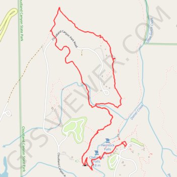
- Distance: 7.9 Km
- Elevation gain: 307 m
- Maximum elevation: 583 m
- Elevation loss: 307 m
- Minimum elevation: 499 m
- Moving time: 2 h 23 m
- Moving speed: 3.3 Km/h
- Maximum speed: 12.6 Km/h
- Total time: 2 h 46 m
- Global speed: 2.8 Km/h
Interactive trail map
Trail profile
- Distance: 7.9 Km
- Elevation gain: 307 m
- Maximum elevation: 583 m
- Elevation loss: 307 m
- Minimum elevation: 499 m
- Moving time: 2 h 23 m
- Moving speed: 3.3 Km/h
- Maximum speed: 12.6 Km/h
- Total time: 2 h 46 m
- Global speed: 2.8 Km/h
About this trail
Name: Cloudland Canyon West Rim Loop Trail trail, distance, elevation, map, profile, GPS track
Start: Cloudland Canyon Park Road, Dade County, Georgia, 30738, United States (34.83483 -85.48031)
End: Cloudland Canyon Park Road, Dade County, Georgia, 30738, United States (34.83475 -85.48035)
Coordinates: 34.83206 -85.49016 34.84929 -85.48031
Other hiking, mountain biking, running and outdoor activity trails
Click on a trail to view its statistics, map and profile.
Cloudland Canyon West Rim Loop Trail
United States > Georgia > Dade County
The West Rim Loop Trail at Cloudland Canyon State Park offers hikers breathtaking vistas of the expansive canyon, with its rugged cliffs and dense forests. As the trail meanders along the canyon's edge, it provides multiple overlooks that showcase the park's diverse landscapes, including panoramic views of the…
Distance: 7.9 Km • Elevation gain: 324 m • Maximum elevation: 583 m
Cloudland to Ross Landing
United States > Georgia > Dade County
River to Clouds Route
Distance: 55.4 Km • Elevation gain: 1,108 m • Maximum elevation: 627 m