Thank you for supporting this site ❤️
Make a donation
Make a donation
Gear up for your next adventure:
As an Amazon Associate, this site earns from qualifying purchases at no extra cost to you.
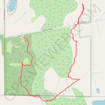
Clarence NY: Tillman Rd Wildlife Management Area southeast trail
Park, trail
- Distance: 2.6 Km
- Elevation gain: 12 m
- Maximum elevation: 234 m
- Elevation loss: 11 m
- Minimum elevation: 226 m
- Moving time: 45 m 22 s
- Moving speed: 3.4 Km/h
- Maximum speed: 7.1 Km/h
- Total time: 59 m 51 s
- Global speed: 2.6 Km/h
Interactive trail map
Thank you for supporting this site ❤️
Make a donation
Make a donation
Gear up for your next adventure:
As an Amazon Associate, this site earns from qualifying purchases at no extra cost to you.
Trail profile
- Distance: 2.6 Km
- Elevation gain: 12 m
- Maximum elevation: 234 m
- Elevation loss: 11 m
- Minimum elevation: 226 m
- Moving time: 45 m 22 s
- Moving speed: 3.4 Km/h
- Maximum speed: 7.1 Km/h
- Total time: 59 m 51 s
- Global speed: 2.6 Km/h
Thank you for supporting this site ❤️
Make a donation
Make a donation
Gear up for your next adventure:
As an Amazon Associate, this site earns from qualifying purchases at no extra cost to you.
About this trail
Name: Clarence NY: Tillman Rd Wildlife Management Area southeast trail trail, distance, elevation, map, profile, GPS track
Coordinates: 42.95460 -78.61074 42.96274 -78.60349
Thank you for supporting this site ❤️
Make a donation
Make a donation
Gear up for your next adventure:
As an Amazon Associate, this site earns from qualifying purchases at no extra cost to you.
Other hiking, mountain biking, running and outdoor activity trails
Click on a trail to view its statistics, map and profile.
Tillman Park one of the loops South of Tillman Road
United States > New York > Erie County > Clarence
Distance: 2.0 Km • Elevation gain: 10 m • Maximum elevation: 234 m