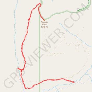
Captain Point
- Distance: 14.7 Km
- Elevation gain: 943 m
- Maximum elevation: 1,705 m
- Elevation loss: 944 m
- Minimum elevation: 906 m
Interactive trail map
Trail profile
- Distance: 14.7 Km
- Elevation gain: 943 m
- Maximum elevation: 1,705 m
- Elevation loss: 944 m
- Minimum elevation: 906 m
About this trail
Name: Captain Point trail, distance, elevation, map, profile, GPS track
Start: Kelley Creek Road, King County, Washington, United States (47.74856 -121.18066)
End: Kelley Creek Road, King County, Washington, United States (47.74857 -121.18076)
Coordinates: 47.74676 -121.20528 47.77170 -121.18066
Other hiking, mountain biking, running and outdoor activity trails
Click on a trail to view its statistics, map and profile.
Northern part of the Pacific Crest Trail (PCT)
United States > Oregon > Klamath County
Hike on the Pacific Crest National Scenic Trail from Crater Lake to Canada Border through Oregon and Washington along the Sierra Nevada and Cascade mountain ranges. #Hiking #Mountain #SierraNevada #Cascade #Nature #Forest #Park #PCT
Distance: 1,198.3 Km • Elevation gain: 44,308 m • Maximum elevation: 2,307 m