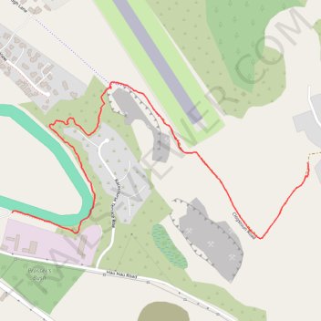
Walking Track behind race course
- Distance: 2.3 Km
- Elevation gain: 4 m
- Maximum elevation: 63 m
- Elevation loss: 53 m
- Minimum elevation: 12 m
- Moving time: 22 m 37 s
- Moving speed: 6.0 Km/h
- Maximum speed: 10.7 Km/h
- Total time: 22 m 37 s
- Global speed: 6.0 Km/h
Interactive trail map
Trail profile
- Distance: 2.3 Km
- Elevation gain: 4 m
- Maximum elevation: 63 m
- Elevation loss: 53 m
- Minimum elevation: 12 m
- Moving time: 22 m 37 s
- Moving speed: 6.0 Km/h
- Maximum speed: 10.7 Km/h
- Total time: 22 m 37 s
- Global speed: 6.0 Km/h
About this trail
Name: Walking Track behind race course trail, distance, elevation, map, profile, GPS track
Start: Clogstoun Road, Hokitika, Westland District, West Coast, 7842, New Zealand (-42.72089 170.99669)
Coordinates: -42.72325 170.98418 -42.71838 170.99674
Other hiking, mountain biking, running and outdoor activity trails
Click on a trail to view its statistics, map and profile.