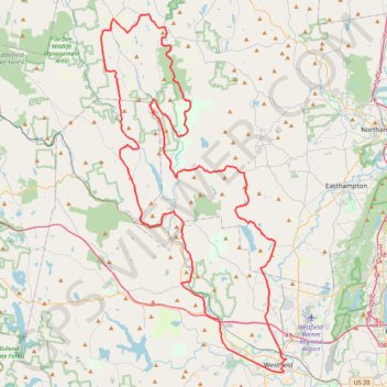
Great River Ride, Gravel Route
- Distance: 117.6 Km
- Elevation gain: 2,106 m
- Maximum elevation: 484 m
- Elevation loss: 2,107 m
- Minimum elevation: 38 m
Interactive trail map
Trail profile
- Distance: 117.6 Km
- Elevation gain: 2,106 m
- Maximum elevation: 484 m
- Elevation loss: 2,107 m
- Minimum elevation: 38 m
About this trail
Name: Great River Ride, Gravel Route trail, distance, elevation, map, profile, GPS track
Start: Sycamore Street, Westfield, Hampden County, Massachusetts, 01085, United States (42.12471 -72.74014)
End: Sycamore Street, Westfield, Hampden County, Massachusetts, 01085, United States (42.12491 -72.74006)
Coordinates: 42.11400 -72.94969 42.41400 -72.73969