Make a donation
Gear up for your next adventure:
As an Amazon Associate, this site earns from qualifying purchases at no extra cost to you.
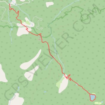
Dry Lake
Interactive trail map
Make a donation
Gear up for your next adventure:
As an Amazon Associate, this site earns from qualifying purchases at no extra cost to you.
Trail profile
- Distance: 17.8 Km
- Elevation gain: 763 m
- Maximum elevation: 2,776 m
- Elevation loss: 763 m
- Minimum elevation: 2,102 m
Make a donation
Gear up for your next adventure:
As an Amazon Associate, this site earns from qualifying purchases at no extra cost to you.
About this trail
Name: Dry Lake trail, distance, elevation, map, profile, GPS track
Start: South Fork Trail, San Bernardino County, California, 92305, United States (34.16111 -116.87174)
End: South Fork Trail, San Bernardino County, California, 92305, United States (34.16113 -116.87175)
Coordinates: 34.11867 -116.87175 34.16123 -116.82602
Make a donation
Gear up for your next adventure:
As an Amazon Associate, this site earns from qualifying purchases at no extra cost to you.
Other hiking, mountain biking, running and outdoor activity trails
Click on a trail to view its statistics, map and profile.
San Gorgonio Mountain (South Fork Trail)
United States > California > San Bernardino County
Hike to San Gorgonio Mountain via South Fork Trail, Poopout Hill, Dollar Lake Saddle, San Bernardino Peak Trail and San Gorgonio Mountain Trail in the Sand to Snow National Monument and the San Gorgonio Wilderness. #Hiking #Mountain #Nature #Forest #Wilderness
Distance: 15.2 Km • Elevation gain: 1,425 m • Maximum elevation: 3,502 m