Thank you for supporting this site ❤️
Make a donation
Make a donation
Gear up for your next adventure:
As an Amazon Associate, this site earns from qualifying purchases at no extra cost to you.
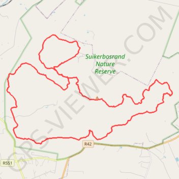
Suikerbosrand Nature Reserve
- Distance: 57.3 Km
- Elevation gain: 1,269 m
- Maximum elevation: 1,901 m
- Elevation loss: 1,271 m
- Minimum elevation: 1,559 m
Interactive trail map
Thank you for supporting this site ❤️
Make a donation
Make a donation
Gear up for your next adventure:
As an Amazon Associate, this site earns from qualifying purchases at no extra cost to you.
Trail profile
- Distance: 57.3 Km
- Elevation gain: 1,269 m
- Maximum elevation: 1,901 m
- Elevation loss: 1,271 m
- Minimum elevation: 1,559 m
Thank you for supporting this site ❤️
Make a donation
Make a donation
Gear up for your next adventure:
As an Amazon Associate, this site earns from qualifying purchases at no extra cost to you.
About this trail
Name: Suikerbosrand Nature Reserve trail, distance, elevation, map, profile, GPS track
Coordinates: -26.54639 28.15451 -26.46530 28.29194
Thank you for supporting this site ❤️
Make a donation
Make a donation
Gear up for your next adventure:
As an Amazon Associate, this site earns from qualifying purchases at no extra cost to you.