Jackson Creek Track
Lake Myrtle. Walls of Jerusalem National Park. #Hiking #WallsOfJerusalem #Tasmania
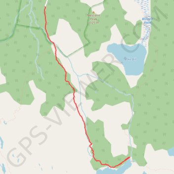
- Distance: 5.9 Km
- Elevation gain: 30 m
- Maximum elevation: 1,047 m
- Elevation loss: 460 m
- Minimum elevation: 602 m
Interactive trail map
Trail profile
- Distance: 5.9 Km
- Elevation gain: 30 m
- Maximum elevation: 1,047 m
- Elevation loss: 460 m
- Minimum elevation: 602 m
About this trail
Name: Jackson Creek Track trail, distance, elevation, map, profile, GPS track
Start: Lake Myrtle Track, Meander Valley, Tasmania, Australia (-41.87595 146.20318)
End: Mose Creek Carpark, Mersey Forest Road, Meander Valley, Tasmania, Australia (-41.84478 146.17967)
Coordinates: -41.87800 146.17958 -41.84478 146.20319