Make a donation
Gear up for your next adventure:
As an Amazon Associate, this site earns from qualifying purchases at no extra cost to you.
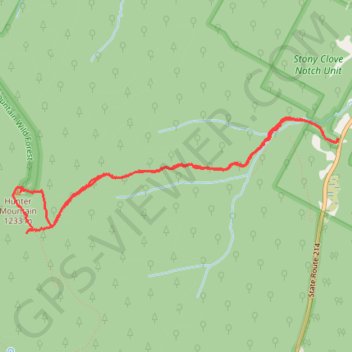
Hunter Mountain Fire Tower and Overlook
Interactive trail map
Make a donation
Gear up for your next adventure:
As an Amazon Associate, this site earns from qualifying purchases at no extra cost to you.
Trail profile
- Distance: 7.9 Km
- Elevation gain: 672 m
- Maximum elevation: 1,225 m
- Elevation loss: 673 m
- Minimum elevation: 559 m
Make a donation
Gear up for your next adventure:
As an Amazon Associate, this site earns from qualifying purchases at no extra cost to you.
About this trail
Name: Hunter Mountain Fire Tower and Overlook trail, distance, elevation, map, profile, GPS track
Coordinates: 42.17463 -74.23090 42.18361 -74.19686
Make a donation
Gear up for your next adventure:
As an Amazon Associate, this site earns from qualifying purchases at no extra cost to you.
Other hiking, mountain biking, running and outdoor activity trails
Click on a trail to view its statistics, map and profile.
Hunter Mountain Loop
United States > New York > Greene County > Town of Hunter > Edgewood
Loop hike to Hunter Mountain via Lane Road, Becker Hollow Trail, Yellow Connector Trail, Hunter Mountain Fire Tower, Hunter Mountain Trail, Yellow Side Trail and Hunter Mountain Overlook in the Hunter-West Kill Wilderness and the Catskill Park. #Hiking #Loop #Mountain #Nature #Forest #Park
Distance: 7.8 Km • Elevation gain: 688 m • Maximum elevation: 1,225 m