Make a donation
Gear up for your next adventure:
As an Amazon Associate, this site earns from qualifying purchases at no extra cost to you.
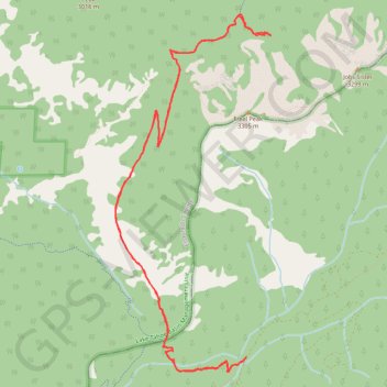
Hike Horse Meadow - Freel Pass
- Distance: 17.3 Km
- Elevation gain: 664 m
- Maximum elevation: 2,966 m
- Elevation loss: 664 m
- Minimum elevation: 2,529 m
- Moving time: 4 h 35 m
- Moving speed: 3.8 Km/h
- Maximum speed: 6.4 Km/h
- Total time: 5 h 22 m
- Global speed: 3.2 Km/h
Interactive trail map
Make a donation
Gear up for your next adventure:
As an Amazon Associate, this site earns from qualifying purchases at no extra cost to you.
Trail profile
- Distance: 17.3 Km
- Elevation gain: 664 m
- Maximum elevation: 2,966 m
- Elevation loss: 664 m
- Minimum elevation: 2,529 m
- Moving time: 4 h 35 m
- Moving speed: 3.8 Km/h
- Maximum speed: 6.4 Km/h
- Total time: 5 h 22 m
- Global speed: 3.2 Km/h
Make a donation
Gear up for your next adventure:
As an Amazon Associate, this site earns from qualifying purchases at no extra cost to you.
About this trail
Name: Hike Horse Meadow - Freel Pass trail, distance, elevation, map, profile, GPS track
Start: Willow Creek Road, Alpine County, California, United States (38.83030 -119.90047)
End: Willow Creek Road, Alpine County, California, United States (38.83036 -119.90042)
Coordinates: 38.82868 -119.91909 38.86838 -119.89684
Make a donation
Gear up for your next adventure:
As an Amazon Associate, this site earns from qualifying purchases at no extra cost to you.
Other hiking, mountain biking, running and outdoor activity trails
Click on a trail to view its statistics, map and profile.
Jobs Peak, Jobs' Sister, Freel Peak and Armstrong Pass loop
United States > California > Alpine County
Distance: 18.5 Km • Elevation gain: 1,179 m • Maximum elevation: 3,310 m