Import a GPX file

June/July: week 5, walk 2/2

  • Distance: 7.2 Km
  • Elevation gain: 20 m
  • Maximum elevation: 30 m
  • Elevation loss: 20 m
  • Minimum elevation: 21 m
  • Moving time: 1 h 4 m
  • Moving speed: 6.7 Km/h
  • Maximum speed: 10.2 Km/h
  • Total time: 1 h 9 m
  • Global speed: 6.2 Km/h

Interactive trail map

Trail profile

  • Distance: 7.2 Km
  • Elevation gain: 20 m
  • Maximum elevation: 30 m
  • Elevation loss: 20 m
  • Minimum elevation: 21 m
  • Moving time: 1 h 4 m
  • Moving speed: 6.7 Km/h
  • Maximum speed: 10.2 Km/h
  • Total time: 1 h 9 m
  • Global speed: 6.2 Km/h

About this trail
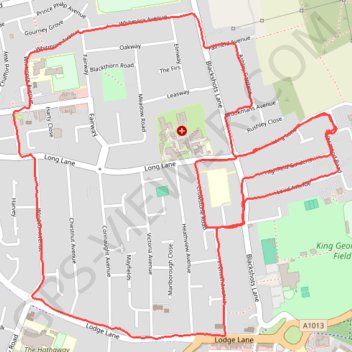
Name: June/July: week 5, walk 2/2 trail, distance, elevation, map, profile, GPS track

Start: Milford Road, Little Thurrock, Grays, Thurrock, Essex, England, RM16 2QR, United Kingdom (51.49684 0.34502)

End: Milford Road, Little Thurrock, Grays, Thurrock, Essex, England, RM16 2QR, United Kingdom (51.49689 0.34512)

Coordinates: 51.48913 0.32628 51.50123 0.34572

Gear up for your next adventure:

🪑Insulated Seat Pad - Protect your seat from cold rocks and wet logs
🛶Waterproof Dry Bags - Keep electronics and clothes dry during river crossings
🎒Hiking Daypack - Lightweight and durable backpacks for day trips and excursions
🧦Outdoor Socks - Durable socks designed for hiking and outdoor sports
🥾Trail Running Shoes - Lightweight and durable shoes for trail running

As an Amazon Associate, this site earns from qualifying purchases at no extra cost to you.