GR 11 FORMIGAL - IBONES DE ANAYET
- Distance: 5.9 Km
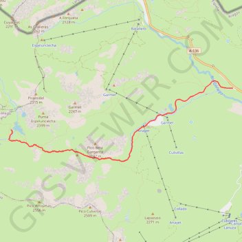
- Elevation gain: 638 m
- Maximum elevation: 2,238 m
- Elevation loss: 30 m
- Minimum elevation: 1,600 m
Interactive trail map
Trail profile
- Distance: 5.9 Km
- Elevation gain: 638 m
- Maximum elevation: 2,238 m
- Elevation loss: 30 m
- Minimum elevation: 1,600 m
About this trail
Name: GR 11 FORMIGAL - IBONES DE ANAYET trail, distance, elevation, map, profile, GPS track
End: Ibones de Anayet, Sallent de Gállego, Alto Gállego, Huesca, Aragon, Spain (42.77855 -0.44553)
Coordinates: 42.77308 -0.44599 42.78708 -0.39286
Other hiking, mountain biking, running and outdoor activity trails
Click on a trail to view its statistics, map and profile.
Southern section — European Divide Trail
France > Auvergne-Rhône-Alpes > Drôme > Valence
Distance: 2,423.8 Km • Elevation gain: 42,375 m • Maximum elevation: 2,005 m
GR 10 - Traversée des Pyrénées
France > Occitania > Pyrénées-Orientales > Banyuls-sur-Mer
Distance: 874.8 Km • Elevation gain: 57,000 m • Maximum elevation: 2,599 m
1 LUCENA - MONTPELLIER
Distance: 2,964.4 Km • Elevation gain: 29,500 m • Maximum elevation: 1,048 m