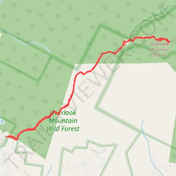
Overlook Mountain Trail
Starting from the Overlook Mountain Trail trailhead, the route climbs steadily through Overlook Mountain Wild Forest on a broad forest track, passing mixed Catskill woodland and the slopes above Mount Guardian.
Higher on the route, the path reaches the atmospheric Overlook Mountain House ruins, then continues toward the summit area and its historic fire tower, a signature Catskill landmark reached by the red-marked Overlook spur.
The reward is a sequence of open ledges and tower views over the Hudson Valley, the surrounding Catskills, the Ashokan Reservoir, and distant ridgelines, making this out-and-back hike a compact route of forest, history, and panorama.
#Hiking #Mountain #Overlook #Forest
- Distance: 7.8 Km
- Elevation gain: 437 m
- Maximum elevation: 943 m
- Elevation loss: 438 m
- Minimum elevation: 534 m
- Moving time: 2 h 15 m
- Moving speed: 3.4 Km/h
- Maximum speed: 14.7 Km/h
- Total time: 2 h 59 m
- Global speed: 2.6 Km/h
Interactive trail map
Trail profile
- Distance: 7.8 Km
- Elevation gain: 437 m
- Maximum elevation: 943 m
- Elevation loss: 438 m
- Minimum elevation: 534 m
- Moving time: 2 h 15 m
- Moving speed: 3.4 Km/h
- Maximum speed: 14.7 Km/h
- Total time: 2 h 59 m
- Global speed: 2.6 Km/h
About this trail
Name: Overlook Mountain Trail trail, distance, elevation, map, profile, GPS track
Coordinates: 42.07073 -74.12255 42.08543 -74.09133
Other hiking, mountain biking, running and outdoor activity trails
Click on a trail to view its statistics, map and profile.
Overlook Mountain via Overlook Spur Trail in Overlook Mountain Wild Forest
United States > New York > Ulster County > Town of Woodstock
The Overlook Mountain hike in New York’s Catskill region is a rewarding journey blending natural beauty with historic intrigue. Hikers ascend through a steady, forested path leading to the eerie ruins of the Overlook Mountain House, an abandoned hotel whose concrete remains invite exploration and reflection.…
Distance: 7.4 Km • Elevation gain: 422 m • Maximum elevation: 943 m
Overlook Mountain via Overlook Spur Trail in Overlook Mountain Wild Forest
United States > New York > Ulster County > Town of Woodstock
Hiking Overlook Mountain via the Overlook Spur Trail offers an enriching journey through both natural beauty and historical remnants. As you ascend the trail, you'll encounter the intriguing ruins of the Overlook Mountain House, a testament to the area's storied past. Upon reaching the summit, the Overlook…
Distance: 7.6 Km • Elevation gain: 432 m • Maximum elevation: 943 m