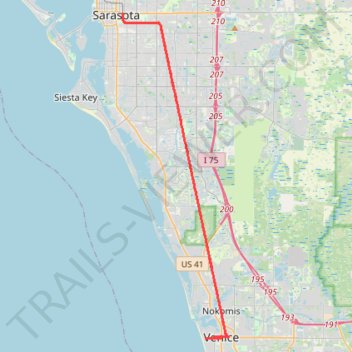
Legacy Trail, Sarasota to Venice Train Depot
- Distance: 64.8 Km
- Elevation gain: 77 m
- Maximum elevation: 16 m
- Elevation loss: 77 m
- Minimum elevation: -1 m
Interactive trail map
Trail profile
- Distance: 64.8 Km
- Elevation gain: 77 m
- Maximum elevation: 16 m
- Elevation loss: 77 m
- Minimum elevation: -1 m
About this trail
Name: Legacy Trail, Sarasota to Venice Train Depot trail, distance, elevation, map, profile, GPS track
Coordinates: 27.09842 -82.52568 27.33741 -82.43742