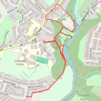
Walk around the paths of the Frome valley near Eastville Park
- Distance: 2.7 Km
- Elevation gain: 66 m
- Maximum elevation: 41 m
- Elevation loss: 66 m
- Minimum elevation: 16 m
- Moving time: 50 m 31 s
- Moving speed: 3.2 Km/h
- Maximum speed: 5.8 Km/h
- Total time: 1 h 16 m
- Global speed: 2.1 Km/h
Interactive trail map
Trail profile
- Distance: 2.7 Km
- Elevation gain: 66 m
- Maximum elevation: 41 m
- Elevation loss: 66 m
- Minimum elevation: 16 m
- Moving time: 50 m 31 s
- Moving speed: 3.2 Km/h
- Maximum speed: 5.8 Km/h
- Total time: 1 h 16 m
- Global speed: 2.1 Km/h
About this trail
Name: Walk around the paths of the Frome valley near Eastville Park trail, distance, elevation, map, profile, GPS track
Coordinates: 51.47800 -2.55569 51.48375 -2.55081
Other hiking, mountain biking, running and outdoor activity trails
Click on a trail to view its statistics, map and profile.
Dean2023-311
United Kingdom > England > Oxfordshire > Oxford
Distance: 310.3 Km • Elevation gain: 3,366 m • Maximum elevation: 290 m