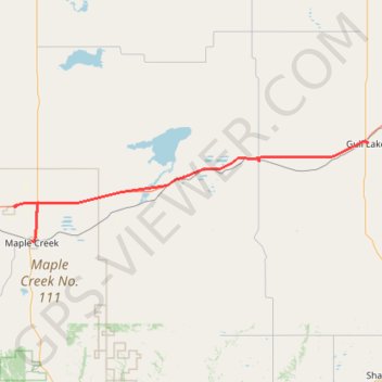
Maple Creek - Gull Lake
- Distance: 98.8 Km
- Elevation gain: 377 m
- Maximum elevation: 810 m
- Elevation loss: 336 m
- Minimum elevation: 757 m
Interactive trail map
Trail profile
- Distance: 98.8 Km
- Elevation gain: 377 m
- Maximum elevation: 810 m
- Elevation loss: 336 m
- Minimum elevation: 757 m
About this trail
Name: Maple Creek - Gull Lake trail, distance, elevation, map, profile, GPS track
End: Gull Lake Campground, 5th Street, Gull Lake, Saskatchewan, S0N 1A0, Canada (50.09732 -108.47683)
Coordinates: 49.90838 -109.53168 50.10147 -108.47662
Topography: Maple Creek No. 111 topographic map, elevation, terrain
Other hiking, mountain biking, running and outdoor activity trails
Click on a trail to view its statistics, map and profile.
Medicine Hat - Maple Creek
Canada > Alberta > Medicine Hat
#Bike #MedicineHat #MapleCreek
Distance: 91.2 Km • Elevation gain: 280 m • Maximum elevation: 834 m
Gull Lake - Swift Current
Canada > Saskatchewan > Gull Lake
Distance: 71.1 Km • Elevation gain: 269 m • Maximum elevation: 800 m
Gull Lake - Swift Current
Canada > Saskatchewan > Gull Lake
Distance: 61.1 Km • Elevation gain: 222 m • Maximum elevation: 800 m