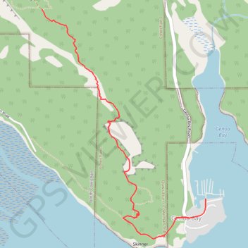
Genoa Bay - Mad Dog Trail
Mount Tzouhalem Ecological Reserve. Vancouver Island. #Hiking #MountTzouhalem #Vancouver
- Distance: 6.4 Km
- Elevation gain: 521 m
- Maximum elevation: 486 m
- Elevation loss: 521 m
- Minimum elevation: 1 m
Interactive trail map
Trail profile
- Distance: 6.4 Km
- Elevation gain: 521 m
- Maximum elevation: 486 m
- Elevation loss: 521 m
- Minimum elevation: 1 m
About this trail
Name: Genoa Bay - Mad Dog Trail trail, distance, elevation, map, profile, GPS track
Coordinates: 48.75644 -123.61515 48.77165 -123.59871
Topography: Cowichan Valley Regional District topographic map, elevation, terrain
Other hiking, mountain biking, running and outdoor activity trails
Click on a trail to view its statistics, map and profile.
BBF loop to the Skydeck in Nanaimo
Canada > British Columbia > Cowichan Valley Regional District > Area A (Mill Bay / Malahat) > Mill Bay
BBF loop to the Skydeck
Distance: 323.5 Km • Elevation gain: 6,222 m • Maximum elevation: 706 m