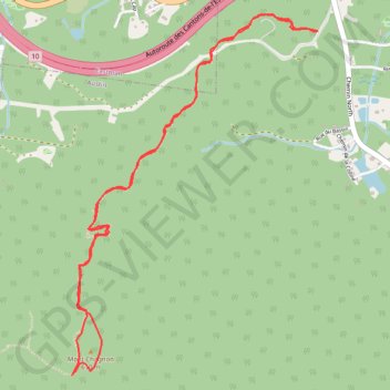
Mont Chagnon
- Distance: 6.2 Km
- Elevation gain: 327 m
- Maximum elevation: 594 m
- Elevation loss: 327 m
- Minimum elevation: 343 m
Interactive trail map
Trail profile
- Distance: 6.2 Km
- Elevation gain: 327 m
- Maximum elevation: 594 m
- Elevation loss: 327 m
- Minimum elevation: 343 m
About this trail
Name: Mont Chagnon trail, distance, elevation, map, profile, GPS track
Coordinates: 45.27153 -72.27888 45.28801 -72.26289
Topography: Memphrémagog topographic map, elevation, terrain
Other hiking, mountain biking, running and outdoor activity trails
Click on a trail to view its statistics, map and profile.