Thank you for supporting this site ❤️
Make a donation
Make a donation
Gear up for your next adventure:
As an Amazon Associate, this site earns from qualifying purchases at no extra cost to you.
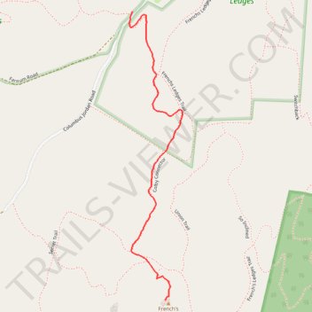
French's Ledges
- Distance: 1.3 Km
- Elevation gain: 46 m
- Maximum elevation: 395 m
- Elevation loss: 3 m
- Minimum elevation: 349 m
- Moving time: 27 m 17 s
- Moving speed: 3.0 Km/h
- Maximum speed: 8.5 Km/h
- Total time: 30 m 52 s
- Global speed: 2.6 Km/h
Interactive trail map
Thank you for supporting this site ❤️
Make a donation
Make a donation
Gear up for your next adventure:
As an Amazon Associate, this site earns from qualifying purchases at no extra cost to you.
Trail profile
- Distance: 1.3 Km
- Elevation gain: 46 m
- Maximum elevation: 395 m
- Elevation loss: 3 m
- Minimum elevation: 349 m
- Moving time: 27 m 17 s
- Moving speed: 3.0 Km/h
- Maximum speed: 8.5 Km/h
- Total time: 30 m 52 s
- Global speed: 2.6 Km/h
Thank you for supporting this site ❤️
Make a donation
Make a donation
Gear up for your next adventure:
As an Amazon Associate, this site earns from qualifying purchases at no extra cost to you.
About this trail
Name: French's Ledges trail, distance, elevation, map, profile, GPS track
Coordinates: 43.54427 -72.28238 43.55277 -72.28020
Thank you for supporting this site ❤️
Make a donation
Make a donation
Gear up for your next adventure:
As an Amazon Associate, this site earns from qualifying purchases at no extra cost to you.
Other hiking, mountain biking, running and outdoor activity trails
Click on a trail to view its statistics, map and profile.