Thank you for supporting this site ❤️
Make a donation
Make a donation
Gear up for your next adventure:
As an Amazon Associate, this site earns from qualifying purchases at no extra cost to you.
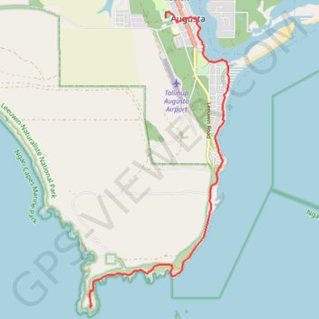
Part 1: Augusta to Cape 7.1 m
- Distance: 11.4 Km
- Elevation gain: 136 m
- Maximum elevation: 41 m
- Elevation loss: 153 m
- Minimum elevation: -2 m
Interactive trail map
Thank you for supporting this site ❤️
Make a donation
Make a donation
Gear up for your next adventure:
As an Amazon Associate, this site earns from qualifying purchases at no extra cost to you.
Trail profile
- Distance: 11.4 Km
- Elevation gain: 136 m
- Maximum elevation: 41 m
- Elevation loss: 153 m
- Minimum elevation: -2 m
Thank you for supporting this site ❤️
Make a donation
Make a donation
Gear up for your next adventure:
As an Amazon Associate, this site earns from qualifying purchases at no extra cost to you.
About this trail
Name: Part 1: Augusta to Cape 7.1 m trail, distance, elevation, map, profile, GPS track
Coordinates: -34.37526 115.13611 -34.31428 115.17100
Thank you for supporting this site ❤️
Make a donation
Make a donation
Gear up for your next adventure:
As an Amazon Associate, this site earns from qualifying purchases at no extra cost to you.
Other hiking, mountain biking, running and outdoor activity trails
Click on a trail to view its statistics, map and profile.
Part 2 38.9m
Distance: 62.7 Km • Elevation gain: 1,036 m • Maximum elevation: 187 m