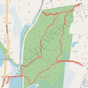
Children's woods - Contoocook Lake Dam
- Distance: 4.4 Km
- Elevation gain: 100 m
- Maximum elevation: 350 m
- Elevation loss: 100 m
- Minimum elevation: 308 m
- Moving time: 1 h 20 m
- Moving speed: 3.3 Km/h
- Maximum speed: 27.5 Km/h
- Total time: 1 h 25 m
- Global speed: 3.1 Km/h
Interactive trail map
Trail profile
- Distance: 4.4 Km
- Elevation gain: 100 m
- Maximum elevation: 350 m
- Elevation loss: 100 m
- Minimum elevation: 308 m
- Moving time: 1 h 20 m
- Moving speed: 3.3 Km/h
- Maximum speed: 27.5 Km/h
- Total time: 1 h 25 m
- Global speed: 3.1 Km/h
About this trail
Name: Children's woods - Contoocook Lake Dam trail, distance, elevation, map, profile, GPS track
Coordinates: 42.80049 -72.02864 42.80866 -72.01803