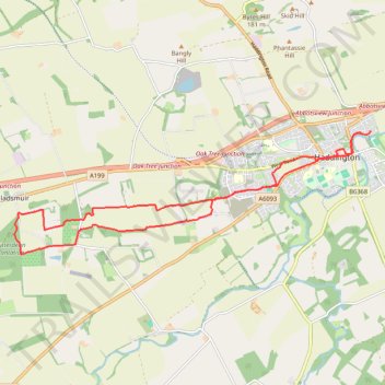
Running near Haddington
- Distance: 15.9 Km
- Elevation gain: 103 m
- Maximum elevation: 112 m
- Elevation loss: 102 m
- Minimum elevation: 44 m
- Moving time: 1 h 42 m
- Moving speed: 9.3 Km/h
- Maximum speed: 13.2 Km/h
- Total time: 1 h 42 m
- Global speed: 9.3 Km/h
Interactive trail map
Trail profile
- Distance: 15.9 Km
- Elevation gain: 103 m
- Maximum elevation: 112 m
- Elevation loss: 102 m
- Minimum elevation: 44 m
- Moving time: 1 h 42 m
- Moving speed: 9.3 Km/h
- Maximum speed: 13.2 Km/h
- Total time: 1 h 42 m
- Global speed: 9.3 Km/h
About this trail
Name: Running near Haddington trail, distance, elevation, map, profile, GPS track
Coordinates: 55.94066 -2.86759 55.95964 -2.77008
Other hiking, mountain biking, running and outdoor activity trails
Click on a trail to view its statistics, map and profile.
Fa'side Castle loop from Wallyford
United Kingdom > Scotland > East Lothian > Musselburgh
Distance: 34.3 Km • Elevation gain: 355 m • Maximum elevation: 136 m