Thank you for supporting this site ❤️
Make a donation
Make a donation
Gear up for your next adventure:
As an Amazon Associate, this site earns from qualifying purchases at no extra cost to you.
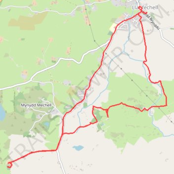
Isle of Anglesey Walking - Llanfechell Loop
- Distance: 8.8 Km
- Elevation gain: 89 m
- Maximum elevation: 71 m
- Elevation loss: 89 m
- Minimum elevation: 28 m
- Moving time: 2 h 31 m
- Moving speed: 3.5 Km/h
- Maximum speed: 5.6 Km/h
- Total time: 3 h 20 m
- Global speed: 2.6 Km/h
Interactive trail map
Thank you for supporting this site ❤️
Make a donation
Make a donation
Gear up for your next adventure:
As an Amazon Associate, this site earns from qualifying purchases at no extra cost to you.
Trail profile
- Distance: 8.8 Km
- Elevation gain: 89 m
- Maximum elevation: 71 m
- Elevation loss: 89 m
- Minimum elevation: 28 m
- Moving time: 2 h 31 m
- Moving speed: 3.5 Km/h
- Maximum speed: 5.6 Km/h
- Total time: 3 h 20 m
- Global speed: 2.6 Km/h
Thank you for supporting this site ❤️
Make a donation
Make a donation
Gear up for your next adventure:
As an Amazon Associate, this site earns from qualifying purchases at no extra cost to you.
About this trail
Name: Isle of Anglesey Walking - Llanfechell Loop trail, distance, elevation, map, profile, GPS track
Coordinates: 53.37237 -4.48245 53.39308 -4.44818
Thank you for supporting this site ❤️
Make a donation
Make a donation
Gear up for your next adventure:
As an Amazon Associate, this site earns from qualifying purchases at no extra cost to you.