Thank you for supporting this site ❤️
Make a donation
Make a donation
Gear up for your next adventure:
As an Amazon Associate, this site earns from qualifying purchases at no extra cost to you.
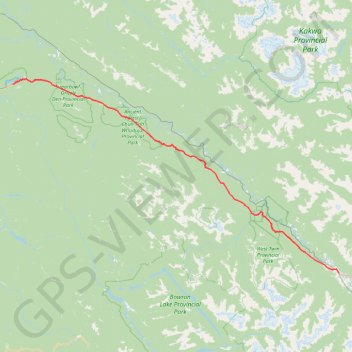
Fraser-Fort George - McBride
#Bike
- Distance: 146.1 Km
- Elevation gain: 1,353 m
- Maximum elevation: 933 m
- Elevation loss: 1,437 m
- Minimum elevation: 666 m
Interactive trail map
Thank you for supporting this site ❤️
Make a donation
Make a donation
Gear up for your next adventure:
As an Amazon Associate, this site earns from qualifying purchases at no extra cost to you.
Trail profile
- Distance: 146.1 Km
- Elevation gain: 1,353 m
- Maximum elevation: 933 m
- Elevation loss: 1,437 m
- Minimum elevation: 666 m
Thank you for supporting this site ❤️
Make a donation
Make a donation
Gear up for your next adventure:
As an Amazon Associate, this site earns from qualifying purchases at no extra cost to you.
About this trail
Name: Fraser-Fort George - McBride trail, distance, elevation, map, profile, GPS track
Coordinates: 53.30966 -121.90853 53.92118 -120.17641
Topography: Area F (Willow River/Upper Fraser) topographic map, elevation, terrain
Thank you for supporting this site ❤️
Make a donation
Make a donation
Gear up for your next adventure:
As an Amazon Associate, this site earns from qualifying purchases at no extra cost to you.