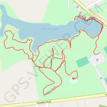
Lake Waterford Park
- Distance: 3.3 Km
- Elevation gain: 30 m
- Maximum elevation: 23 m
- Elevation loss: 30 m
- Minimum elevation: 6 m
- Moving time: 1 h 4 m
- Moving speed: 3.1 Km/h
- Maximum speed: 20.3 Km/h
- Total time: 1 h 11 m
- Global speed: 2.7 Km/h
Interactive trail map
Trail profile
- Distance: 3.3 Km
- Elevation gain: 30 m
- Maximum elevation: 23 m
- Elevation loss: 30 m
- Minimum elevation: 6 m
- Moving time: 1 h 4 m
- Moving speed: 3.1 Km/h
- Maximum speed: 20.3 Km/h
- Total time: 1 h 11 m
- Global speed: 2.7 Km/h
About this trail
Name: Lake Waterford Park trail, distance, elevation, map, profile, GPS track
Coordinates: 39.11097 -76.56439 39.11479 -76.55846
Other hiking, mountain biking, running and outdoor activity trails
Click on a trail to view its statistics, map and profile.
Lake Waterford
United States > Maryland > Anne Arundel County > Pasadena
Distance: 2.1 Km • Elevation gain: 24 m • Maximum elevation: 22 m