Thank you for supporting this site ❤️
Make a donation
Make a donation
Gear up for your next adventure:
As an Amazon Associate, this site earns from qualifying purchases at no extra cost to you.
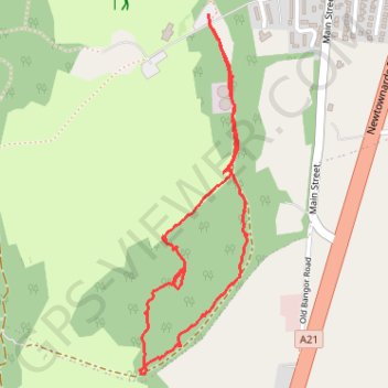
Conlig Wood main path
County Down Hiking
- Distance: 2.7 Km
- Elevation gain: 66 m
- Maximum elevation: 136 m
- Elevation loss: 66 m
- Minimum elevation: 86 m
- Moving time: 55 m 48 s
- Moving speed: 2.9 Km/h
- Maximum speed: 6.2 Km/h
- Total time: 1 h 23 m
- Global speed: 2.0 Km/h
Interactive trail map
Thank you for supporting this site ❤️
Make a donation
Make a donation
Gear up for your next adventure:
As an Amazon Associate, this site earns from qualifying purchases at no extra cost to you.
Trail profile
- Distance: 2.7 Km
- Elevation gain: 66 m
- Maximum elevation: 136 m
- Elevation loss: 66 m
- Minimum elevation: 86 m
- Moving time: 55 m 48 s
- Moving speed: 2.9 Km/h
- Maximum speed: 6.2 Km/h
- Total time: 1 h 23 m
- Global speed: 2.0 Km/h
Thank you for supporting this site ❤️
Make a donation
Make a donation
Gear up for your next adventure:
As an Amazon Associate, this site earns from qualifying purchases at no extra cost to you.
About this trail
Name: Conlig Wood main path trail, distance, elevation, map, profile, GPS track
Start: Main Street, Conlig, County Down, Northern Ireland, BT19 7TA, United Kingdom (54.62656 -5.68281)
End: Main Street, Conlig, County Down, Northern Ireland, BT19 7TA, United Kingdom (54.62659 -5.68283)
Coordinates: 54.61801 -5.68564 54.62659 -5.68119
Thank you for supporting this site ❤️
Make a donation
Make a donation
Gear up for your next adventure:
As an Amazon Associate, this site earns from qualifying purchases at no extra cost to you.