Turtlehead Peak
Hike to the Turtlehead Peak via the Calico Tanks Trail and the Turtlehead Peak Trail in the La Madre Mountain Wilderness and the Red Rock Canyon National Conservation Area. #Hiking #Mountain #Nature #Desert #Wilderness #Canyon
- Distance: 3.8 Km
- Elevation gain: 577 m
- Maximum elevation: 1,896 m
- Elevation loss: 35 m
- Minimum elevation: 1,318 m
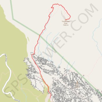
Interactive trail map
Trail profile
- Distance: 3.8 Km
- Elevation gain: 577 m
- Maximum elevation: 1,896 m
- Elevation loss: 35 m
- Minimum elevation: 1,318 m
About this trail
Name: Turtlehead Peak trail, distance, elevation, map, profile, GPS track
Start: Sandstone Quarry Parking, Red Rock Canyon, Clark County, Nevada, United States (36.16242 -115.45038)
End: Turtlehead Peak Trail, Clark County, Nevada, United States (36.18023 -115.44598)
Coordinates: 36.16242 -115.45552 36.18381 -115.44468
Other hiking, mountain biking, running and outdoor activity trails
Click on a trail to view its statistics, map and profile.
Turtlehead Peak Trail in Red Rock Canyon National Conservation Area
United States > Nevada > Clark County
Turtlehead Peak Trail offers a fantastic blend of natural beauty and a bit of a workout. The hike takes you past ancient petroglyphs and up to a ridge with amazing views of Las Vegas and the stunning sandstone formations around you. While the trail can be rocky and steep in sections, the sense of…
Distance: 7.6 Km • Elevation gain: 612 m • Maximum elevation: 1,898 m
Calico Tanks Trail in Red Rock Canyon National Conservation Area
United States > Nevada > Clark County
The Calico Tanks Trail is a fantastic way to immerse yourself in the beauty of nature while enjoying some stunning views of the Las Vegas skyline. The trail is well-marked and provides a great workout, making it easy to explore the unique sandstone formations along the way. Starting early is a smart choice, as…
Distance: 4.0 Km • Elevation gain: 143 m • Maximum elevation: 1,448 m