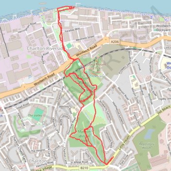
Maryon Wilson Park to Thames Barrier Loop
Loop hike from Cemetery Lane to Maryon Wilson Park, Maryon Park, Moore Park and Thames Barrier. #Hiking #Loop #London #Park #Nature #River #City #Forest
- Distance: 5.8 Km
- Elevation gain: 89 m
- Maximum elevation: 45 m
- Elevation loss: 90 m
- Minimum elevation: 1 m
- Moving time: 1 h 24 m
- Moving speed: 4.1 Km/h
- Maximum speed: 8.0 Km/h
- Total time: 1 h 32 m
- Global speed: 3.7 Km/h
Interactive trail map
Trail profile
- Distance: 5.8 Km
- Elevation gain: 89 m
- Maximum elevation: 45 m
- Elevation loss: 90 m
- Minimum elevation: 1 m
- Moving time: 1 h 24 m
- Moving speed: 4.1 Km/h
- Maximum speed: 8.0 Km/h
- Total time: 1 h 32 m
- Global speed: 3.7 Km/h
About this trail
Name: Maryon Wilson Park to Thames Barrier Loop trail, distance, elevation, map, profile, GPS track
Coordinates: 51.48228 0.03918 51.49544 0.04665
Other hiking, mountain biking, running and outdoor activity trails
Click on a trail to view its statistics, map and profile.
London Marathon
United Kingdom > England > London
Distance: 42.2 Km • Elevation gain: 281 m • Maximum elevation: 50 m