
Grant Grove Village to Sequoia Lake Loop
Loop hike from Grant Grove Village to Sequoia Lake via Sunset Trail, Ella Falls, Dead Giant Loop Trail, Sequoia Lake Overlook, North Grove Trail, Centennial Stump, General Grant Tree, Tennessee Tree, Michigan Tree and South Boundary Trail in the Kings Canyon National Park and the Giant Sequoia National Forest. #Hiking #Loop #Nature #Forest #Falls #Lake #Mountain #Park
- Distance: 17.5 Km
- Elevation gain: 643 m
- Maximum elevation: 2,023 m
- Elevation loss: 643 m
- Minimum elevation: 1,646 m
Interactive trail map
Trail profile
- Distance: 17.5 Km
- Elevation gain: 643 m
- Maximum elevation: 2,023 m
- Elevation loss: 643 m
- Minimum elevation: 1,646 m
About this trail
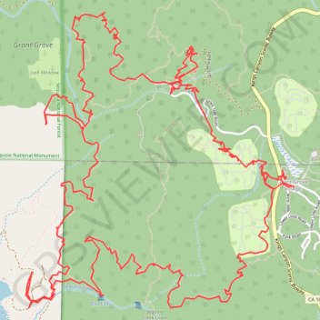
Name: Grant Grove Village to Sequoia Lake Loop trail, distance, elevation, map, profile, GPS track
Coordinates: 36.73136 -118.98580 36.75201 -118.96244
Other hiking, mountain biking, running and outdoor activity trails
Click on a trail to view its statistics, map and profile.
Sequoia National Park - Converse Basin Grove
United States > California > Fresno County > Yokuts Valley
Giant Sequoia National Monument
Distance: 53.3 Km • Elevation gain: 1,956 m • Maximum elevation: 2,095 m