Thank you for supporting this site ❤️
Make a donation
Make a donation
Gear up for your next adventure:
As an Amazon Associate, this site earns from qualifying purchases at no extra cost to you.
Exeter Walking
Interactive trail map
Thank you for supporting this site ❤️
Make a donation
Make a donation
Gear up for your next adventure:
As an Amazon Associate, this site earns from qualifying purchases at no extra cost to you.
Trail profile
- Distance: 5.2 Km
- Elevation gain: 20 m
- Maximum elevation: 19 m
- Elevation loss: 20 m
- Minimum elevation: 6 m
- Moving time: 1 h 19 m
- Moving speed: 3.9 Km/h
- Maximum speed: 6.5 Km/h
- Total time: 1 h 19 m
- Global speed: 3.9 Km/h
Thank you for supporting this site ❤️
Make a donation
Make a donation
Gear up for your next adventure:
As an Amazon Associate, this site earns from qualifying purchases at no extra cost to you.
About this trail
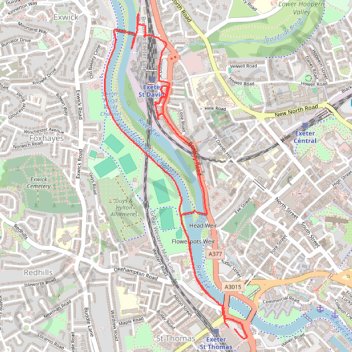
Name: Exeter Walking trail, distance, elevation, map, profile, GPS track
Start: Alphington Street, St Thomas, Exeter, Devon, England, EX2 8AF, United Kingdom (50.71732 -3.53743)
End: Alphington Street, St Thomas, Exeter, Devon, England, EX2 8AF, United Kingdom (50.71739 -3.53784)
Coordinates: 50.71685 -3.54717 50.73235 -3.53648
Thank you for supporting this site ❤️
Make a donation
Make a donation
Gear up for your next adventure:
As an Amazon Associate, this site earns from qualifying purchases at no extra cost to you.