Thank you for supporting this site ❤️
Make a donation
Make a donation
Gear up for your next adventure:
As an Amazon Associate, this site earns from qualifying purchases at no extra cost to you.
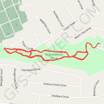
Troy Kiwanis Park main trail asphalt paved
- Distance: 4.9 Km
- Elevation gain: 30 m
- Maximum elevation: 174 m
- Elevation loss: 30 m
- Minimum elevation: 165 m
- Moving time: 54 m 22 s
- Moving speed: 5.4 Km/h
- Maximum speed: 8.6 Km/h
- Total time: 54 m 22 s
- Global speed: 5.4 Km/h
Interactive trail map
Thank you for supporting this site ❤️
Make a donation
Make a donation
Gear up for your next adventure:
As an Amazon Associate, this site earns from qualifying purchases at no extra cost to you.
Trail profile
- Distance: 4.9 Km
- Elevation gain: 30 m
- Maximum elevation: 174 m
- Elevation loss: 30 m
- Minimum elevation: 165 m
- Moving time: 54 m 22 s
- Moving speed: 5.4 Km/h
- Maximum speed: 8.6 Km/h
- Total time: 54 m 22 s
- Global speed: 5.4 Km/h
Thank you for supporting this site ❤️
Make a donation
Make a donation
Gear up for your next adventure:
As an Amazon Associate, this site earns from qualifying purchases at no extra cost to you.
About this trail
Name: Troy Kiwanis Park main trail asphalt paved trail, distance, elevation, map, profile, GPS track
Start: Beech Tree Drive, Troy, Lincoln County, Missouri, 63379, United States (38.97041 -90.98270)
End: Beech Tree Drive, Troy, Lincoln County, Missouri, 63379, United States (38.97041 -90.98275)
Coordinates: 38.96934 -90.99031 38.97045 -90.98270
Thank you for supporting this site ❤️
Make a donation
Make a donation
Gear up for your next adventure:
As an Amazon Associate, this site earns from qualifying purchases at no extra cost to you.