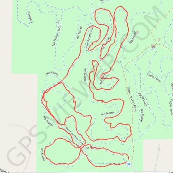
Ingawanis Woodland trails
- Distance: 3.8 Km
- Elevation gain: 40 m
- Maximum elevation: 291 m
- Elevation loss: 41 m
- Minimum elevation: 279 m
- Moving time: 1 h 6 m
- Moving speed: 3.4 Km/h
- Maximum speed: 8.4 Km/h
- Total time: 1 h 8 m
- Global speed: 3.3 Km/h
Interactive trail map
Trail profile
- Distance: 3.8 Km
- Elevation gain: 40 m
- Maximum elevation: 291 m
- Elevation loss: 41 m
- Minimum elevation: 279 m
- Moving time: 1 h 6 m
- Moving speed: 3.4 Km/h
- Maximum speed: 8.4 Km/h
- Total time: 1 h 8 m
- Global speed: 3.3 Km/h
About this trail
Name: Ingawanis Woodland trails trail, distance, elevation, map, profile, GPS track
Start: Lower Access Path, Bremer County, Iowa, United States (42.67182 -92.42118)
End: Upper Access Path, Bremer County, Iowa, United States (42.67175 -92.42127)
Coordinates: 42.67161 -92.42462 42.67626 -92.42108
Other hiking, mountain biking, running and outdoor activity trails
Click on a trail to view its statistics, map and profile.
Ingawanis Woodland trails
United States > Iowa > Bremer County
Distance: 7.5 Km • Elevation gain: 72 m • Maximum elevation: 297 m
Ingawanis Woodland Loop
United States > Iowa > Bremer County
Distance: 4.8 Km • Elevation gain: 62 m • Maximum elevation: 301 m
Ingawanis Woodland
United States > Iowa > Bremer County
Distance: 3.4 Km • Elevation gain: 42 m • Maximum elevation: 297 m