0918112102-54209
- Distance: 0.5 Km
- Elevation gain: 3 m
- Maximum elevation: 18 m
- Elevation loss: 0 m
- Minimum elevation: 15 m
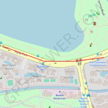
Interactive trail map
Trail profile
- Distance: 0.5 Km
- Elevation gain: 3 m
- Maximum elevation: 18 m
- Elevation loss: 0 m
- Minimum elevation: 15 m
About this trail
Name: 0918112102-54209 trail, distance, elevation, map, profile, GPS track
Start: Bedok Reservoir Road, Bedok, Southeast, Singapore, 479233, Singapore (1.33814 103.93412)
End: Bedok Reservoir Road, Bedok, Northeast, Singapore, 479258, Singapore (1.33862 103.92963)
Coordinates: 1.33797 103.92963 1.33862 103.93412