Upper Captain Ahab Loop Trail
The Upper Captain Ahab Loop Trail offers an exhilarating hike, featuring stunning desert landscapes and rugged terrain. As you traverse the winding path, you'll be treated to sweeping views of the Moab valley, the La Sal Mountains in the distance, and the Colorado River below. The trail is a technical challenge with rocky sections, steep ascents, and sharp turns, providing a thrilling experience for those ready to engage with its demanding features. It's a great way to immerse yourself in Moab's natural beauty, though hikers should be prepared for little shade and carry ample water. #Hiking #Loop #Canyon #Dsert #Rock #River #Nature
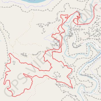
- Distance: 13.9 Km
- Elevation gain: 537 m
- Maximum elevation: 1,494 m
- Elevation loss: 558 m
- Minimum elevation: 1,221 m
Interactive trail map
Trail profile
- Distance: 13.9 Km
- Elevation gain: 537 m
- Maximum elevation: 1,494 m
- Elevation loss: 558 m
- Minimum elevation: 1,221 m
About this trail
Name: Upper Captain Ahab Loop Trail trail, distance, elevation, map, profile, GPS track
Start: Kane Springs Road, Grand County, Utah, United States (38.52574 -109.59717)
End: Kane Springs Road, Grand County, Utah, United States (38.52824 -109.59636)
Coordinates: 38.50908 -109.62113 38.52824 -109.59636