Little Wild Horse Canyon and Bell Canyon Loop in Muddy Creek Wilderness
This loop in the San Rafael Swell is a stunning desert hike that showcases the area's unique geological formations. The trail offers an exciting mix of narrow slot canyons, open desert vistas, and colorful rock walls. As you navigate through Little Wild Horse Canyon, you'll encounter smooth, undulating sandstone that sometimes constricts to razor-thin passages, providing a thrilling yet accessible experience. Bell Canyon, while broader, still captivates with its impressive cliffs and dramatic desert landscape. The hike provides diverse scenery, from sunlit canyon floors to shady, cool spots within the narrowest sections of the slots, making it a memorable adventure for all levels. #Hiking #Canyon #Desert #Rock #Nature
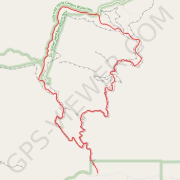
- Distance: 13.0 Km
- Elevation gain: 640 m
- Maximum elevation: 1,735 m
- Elevation loss: 640 m
- Minimum elevation: 1,512 m
Interactive trail map
Trail profile
- Distance: 13.0 Km
- Elevation gain: 640 m
- Maximum elevation: 1,735 m
- Elevation loss: 640 m
- Minimum elevation: 1,512 m
About this trail
Name: Little Wild Horse Canyon and Bell Canyon Loop in Muddy Creek Wilderness trail, distance, elevation, map, profile, GPS track
Start: Little Wild Horse & Bell Canyon Trail, Emery County, Utah, United States (38.58294 -110.80290)
End: Little Wild Horse & Bell Canyon Trail, Emery County, Utah, United States (38.58294 -110.80290)
Coordinates: 38.58294 -110.81838 38.61708 -110.79152
Other hiking, mountain biking, running and outdoor activity trails
Click on a trail to view its statistics, map and profile.
Little Wild Horse Canyon Trail in Muddy Creek Wilderness
United States > Utah > Emery County
The Little Wild Horse Canyon Trail offers an unforgettable journey through the rugged terrain of the San Rafael Swell. As you venture into the narrow slot canyon, the towering red rock walls gradually close in, creating an awe-inspiring atmosphere that contrasts with the wide, open desert landscapes at the…
Distance: 5.8 Km • Elevation gain: 400 m • Maximum elevation: 1,687 m