Thank you for supporting this site ❤️
Make a donation
Make a donation
Gear up for your next adventure:
As an Amazon Associate, this site earns from qualifying purchases at no extra cost to you.
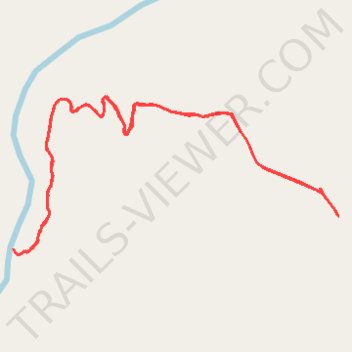
East Fork Obey River
- Distance: 4.9 Km
- Elevation gain: 223 m
- Maximum elevation: 534 m
- Elevation loss: 223 m
- Minimum elevation: 326 m
- Moving time: 47 m 57 s
- Moving speed: 6.1 Km/h
- Maximum speed: 26.5 Km/h
- Total time: 1 h 3 m
- Global speed: 4.6 Km/h
Interactive trail map
Thank you for supporting this site ❤️
Make a donation
Make a donation
Gear up for your next adventure:
As an Amazon Associate, this site earns from qualifying purchases at no extra cost to you.
Trail profile
- Distance: 4.9 Km
- Elevation gain: 223 m
- Maximum elevation: 534 m
- Elevation loss: 223 m
- Minimum elevation: 326 m
- Moving time: 47 m 57 s
- Moving speed: 6.1 Km/h
- Maximum speed: 26.5 Km/h
- Total time: 1 h 3 m
- Global speed: 4.6 Km/h
Thank you for supporting this site ❤️
Make a donation
Make a donation
Gear up for your next adventure:
As an Amazon Associate, this site earns from qualifying purchases at no extra cost to you.
About this trail
Name: East Fork Obey River trail, distance, elevation, map, profile, GPS track
Start: Fentress County, Middle Tennessee, Tennessee, 38565, United States (36.24802 -85.03259)
End: Fentress County, Middle Tennessee, Tennessee, 38565, United States (36.24810 -85.03266)
Coordinates: 36.24669 -85.04687 36.25227 -85.03259
Thank you for supporting this site ❤️
Make a donation
Make a donation
Gear up for your next adventure:
As an Amazon Associate, this site earns from qualifying purchases at no extra cost to you.