Make a donation
Gear up for your next adventure:
As an Amazon Associate, this site earns from qualifying purchases at no extra cost to you.
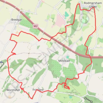
Rodmersham to Frinsted Loop
- Distance: 19.2 Km
- Elevation gain: 288 m
- Maximum elevation: 159 m
- Elevation loss: 288 m
- Minimum elevation: 36 m
- Moving time: 3 h 45 m
- Moving speed: 5.1 Km/h
- Maximum speed: 12.6 Km/h
- Total time: 4 h 39 m
- Global speed: 4.1 Km/h
Interactive trail map
Make a donation
Gear up for your next adventure:
As an Amazon Associate, this site earns from qualifying purchases at no extra cost to you.
Trail profile
- Distance: 19.2 Km
- Elevation gain: 288 m
- Maximum elevation: 159 m
- Elevation loss: 288 m
- Minimum elevation: 36 m
- Moving time: 3 h 45 m
- Moving speed: 5.1 Km/h
- Maximum speed: 12.6 Km/h
- Total time: 4 h 39 m
- Global speed: 4.1 Km/h
Make a donation
Gear up for your next adventure:
As an Amazon Associate, this site earns from qualifying purchases at no extra cost to you.
About this trail
Name: Rodmersham to Frinsted Loop trail, distance, elevation, map, profile, GPS track
Coordinates: 51.27966 0.69051 51.31950 0.74971
Make a donation
Gear up for your next adventure:
As an Amazon Associate, this site earns from qualifying purchases at no extra cost to you.
Other hiking, mountain biking, running and outdoor activity trails
Click on a trail to view its statistics, map and profile.
Hollingbourne Hill Loop
United Kingdom > England > Kent > Borough of Swale > Rodmersham Green
Distance: 31.4 Km • Elevation gain: 390 m • Maximum elevation: 198 m
Doddington 10 mile loop
United Kingdom > England > Kent > Borough of Swale > Rodmersham Green
Distance: 16.3 Km • Elevation gain: 198 m • Maximum elevation: 109 m
Bottom Pond Loop
United Kingdom > England > Kent > Borough of Swale > Rodmersham Green
Distance: 15.5 Km • Elevation gain: 227 m • Maximum elevation: 114 m
High Wood Loop
United Kingdom > England > Kent > Borough of Swale > Rodmersham Green
Distance: 16.9 Km • Elevation gain: 196 m • Maximum elevation: 142 m
Make a donation
Gear up for your next adventure:
As an Amazon Associate, this site earns from qualifying purchases at no extra cost to you.
Borden loop
United Kingdom > England > Kent > Borough of Swale > Rodmersham Green
Distance: 12.6 Km • Elevation gain: 125 m • Maximum elevation: 79 m